
This year’s hot spot for Atlantic tropical-cyclone development – the area north and northeast of the Caribbean – was shifting into overdrive on Friday. Two cheek-by-jowl tropical systems have emerged, one already a quickly strengthening hurricane and the other likely to become a named storm as it rolls through the Bahamas this weekend. Multiple models suggest that the second system, a disturbance called Invest 94L, could reach the Southeast U.S. coast as a strong tropical storm or hurricane early next week. See below for more on the still-murky but eyebrow-raising possibilities for 94L.
Humberto flexes its muscles in the open Northwest Atlantic
Former Tropical Storm Humberto became the Atlantic season’s third hurricane at 5 a.m. EDT Friday, September 26. That’s almost three weeks beyond the average arrival date of the season’s third hurricane (September 7), based on 1991-2020 data. As of 11 a.m. EDT Friday, Humberto was located about 450 miles (725 kilometers) northeast of the northern Leeward Islands, moving northwest at 5 mph with Category 1 sustained winds of 90 mph (150 km/h).
The year’s first two hurricanes, Erin and Gabrielle, ended up reaching Cat 5 and Cat 4 strength, respectively, and Humberto is now expected to hit that rarefied Cat 4/5 range as well. Humberto was rapidly organizing on Friday, with a fast-sharpening eye evident on satellite imagery by midday. Upper-level outflow was still slightly restricted toward the west, perhaps in part because of interaction with 94L, but wind shear overall was less than expected and is now predicted to remain at generally 10-12 knots or less through early next week. The atmosphere around Humberto will be moistening, and the hurricane will be traversing water around 29 degrees Celsius (84 degrees Fahrenheit), roughly 1°C (2°F) warmer than average.
As of early Friday, all four of NOAA’s high-resolution intensity models (HWRF, HMON, HAFS-A, and HAFS-B) were bringing Humberto to a peak of Cat 4 strength by Sunday/Monday. It’s worth noting that the DTOPS statistical guidance from Friday morning gave an 87% chance of Humberto becoming a 150-mph high-end Cat 4 by Sunday. The National Hurricane Center forecast from 11 a.m. EDT Friday topped out Humberto as a Cat 4 with 145-mph winds on Sunday. If Humberto does get this strong, it wouldn’t be a shock to see it happen as soon as Saturday afternoon or evening.

Ensemble model tracks are tightly clustered around a recurving track well east of the U.S. Coast and west of Bermuda, as reflected in the official NHC forecast. However, Bermuda will be on the stronger right-hand side of Humberto, and some ensemble tracks bring the hurricane close enough for potential impacts by midweek, so residents should remain vigilant. Multiple days of large swells and life-threatening rip currents can once again be expected across the Bahamas, northern shores of the Greater Antilles, and much of the U.S. East Coast. Later next week, Humberto is expected to accelerate northeast, perhaps reaching Iceland or the British Isles as a potent post-tropical storm in around 8 to 10 days.
Many possible futures for 94L – some worse than others
As of midday Friday, 94L remained a sprawling but poorly organized disturbance, with a large expanse of showers and thunderstorms (convection) surrounding Hispaniola and eastern Cuba. The system’s proximity to land and to Humberto was disrupting its ability to organize, and wind shear is a bit higher for 94L than for Humberto (mostly around 15 knots). However, 94L is embedded in a moist midlevel atmosphere (relative humidity around 65 percent), and it will be traversing very warm waters of around 30°C (86°F), again roughly 1°C (2°F) warmer than average for the date.
As shown in Figure 2, the unusual oceanic warmth around the Southeast Bahamas – where 94L will be gathering strength on Saturday – was made 100 to 500 times more likely by long-term human-caused climate change. Deep oceanic heat content will also be relatively high below 94L’s path.

NHC reported signs on Friday afternoon that a low pressure center was starting to form between eastern Cuba and the southeastern Bahamas. In its 2 p.m. Friday Tropical Weather Outlook, NHC gave 94L a 90% chance of becoming at least a tropical depression in the next 48 hours. How quickly 94L can consolidate on Saturday and how quickly it moves northward will be critical for its future and for potential impacts from the Bahamas to the Southeast United States. The size of 94L’s eventual circulation will also make a difference: a smaller core could both intensify and weaken more quickly. Intensity models are inherently less reliable until a closed circulation can be tracked and modeled, but for what it’s worth, there was strong agreement among those models and multiple ensemble models on Friday that 94L will be moving through the Bahamas as a tropical depression or tropical storm on Sunday.
What happens beyond that point is as clear as the proverbial mud. A key aspect of 94L’s track will be the future of an upper low tracking through the Northeast U.S. Part of this upper low is predicted to be left behind over the Southeast, and that process – where timing and location are always challenging to nail down – could help pull 94L onshore and even well inland, where heavy rain would become a significant concern.
Another variable is the close presence of Humberto, which will be by far the more powerful of the two cyclones over the next several days. Humberto and 94L will be close enough for some influence from the Fujiwhara effect (see explainer from the Hong Kong Observatory), but because the two cyclones are such unequal partners, a classic rotating-around-each-other Fujiwhara pattern isn’t likely. If anything, Humberto might pull 94L into its orbit, keeping it from moving well inland.
The Euro and GFS ensemble output from 6Z Friday, shown in Figure 3, suggests strong agreement that 94L will reach the Southeast U.S. Coast around Monday or Tuesday, but with sharp differences on location and timing.

A group of four model ensembles from 0Z Friday, summarized below in Figure 4, shows even starker divergence on 94L’s longer-term future. Many of the GFS solutions, including the operational run (green line), favor the well-inland track described above, while the operational Euro run stalls 94L just off the coast of South Carolina. A number of solutions from the Google AI ensemble are in between, pushing 94L some distance into South Carolina before a sharp right turn back offshore.
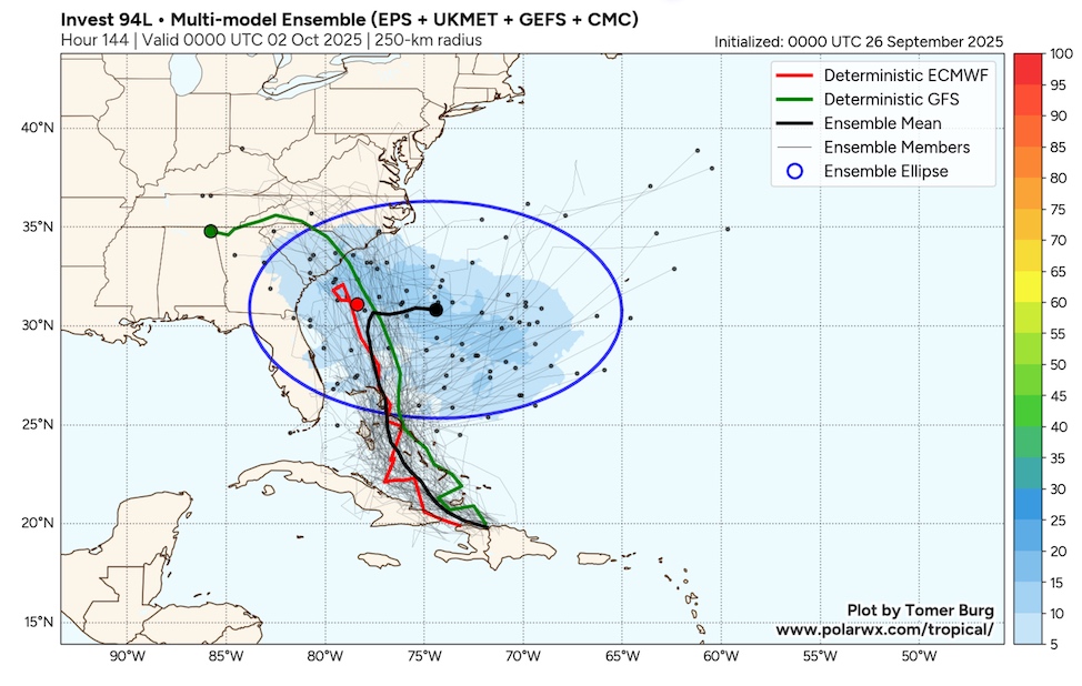
Given this amount of uncertainty, residents of the Southeast U.S., including the coastlines from Florida to North Carolina as well as the eastern slopes of the southern Appalachians, would be prudent to approach the risks of various 94L as very real but far from set in stone for now. Any stalling of 94L well inland could bring heavy rain to some of the areas devastated by Hurricane Helene roughly a year ago. This setup wouldn’t have the one-two punch of the torrential rains that fell just ahead of Helene itself and propelled that event into truly catastrophic territory. Still, any tropical system moving slowly inland would obviously be enormously stressful for those who experienced Helene a year ago, and any stalling out could lead to some pockets of very heavy rain, as suggested by the inland-moving GFS model runs.
That said, it’s still too soon to seize on any one model solution, especially beyond the next several days. As the National Weather Service in Wakefield, Virginia, warned in a Friday-afternoon tweet, “Be cautious of what information you follow/look at online as models continue to change.”
Gabrielle brings fierce winds to the Azores as a post-tropical cyclone
Hurricane Gabrielle transitioned into a post-tropical cyclone just a few hours before reaching the central Azores early Friday, but the still-strong storm brought a few hurricane-level impacts nevertheless, including torrential rains, huge waves, and high winds. Gabrielle’s center passed over or very near Pico, Saõ Jorge, and Terceira islands around 6 a.m. Friday local time (2 a.m. Friday EDT). According to NHC, a sustained wind of 71 mph (114 km/h) with a gust to 86 mph (138 km/h) was reported at an elevation of 884 feet (269 m) on Terceira, which is dominated by the cinder cone of dormant volcano Santa Bárbara. Near the peak of the cone, which rises to 3,350 ft (1,021 m), a wind gust of 115 mph (185 km/h) was recorded. A wind gust to 58 mph (93 km/h) was measured near sea level at Ponta Furada on Faial Island. Several homes were damaged and a number of trees and power lines were felled across the Azores, according to Euronews, but there were no reports of injuries.
Gabrielle is predicted to reach the central coast of Portugal, perhaps affecting the Lisbon area, on Sunday morning as a post-tropical cyclone, still packing sustained winds of 40 mph (65 km/h) comparable to a low-end tropical storm. Gusts could reach 45 to 50 mph.
Jeff Masters contributed to this post.
![]()
![]()
