
The mapping activity sparked a lot of animated discussion among the participants as they shared their observations and experiences with various locations and nature-based solutions.
There are many different perspectives and visions for Detroit’s past, present, and future. Some of these perspectives have focused on the idea of emptiness, depicting spaces as lacking connections or relationships. Maps have played a key role in reinforcing this idea of “emptiness” by highlighting areas of low density and vacant land. Detroit has a complicated history with maps, not only by emphasizing emptiness but also through the redlining maps that labeled Black neighborhoods as “hazardous”. More recently, the Detroit Future City (DFC) Strategic Vision (2012) mapped “vacant” neighborhoods and proposed transforming them into “Innovation Ecological’’ landscapes. While these proposals were not fully realized, they contributed to negative perceptions of city greening efforts, with some fearing that such initiatives would displace communities.
By portraying places as “empty” on maps, we risk overlooking the care, relationships, connections, and plurality of knowledge and practices that actually exist in these areas. On March 24, 2025, we organized a participatory (counter) mapping workshop in Detroit, where we aimed to tell a different story: Detroit is not empty. By co-developing maps that visualize networks of people, nature, and their relationships, we aimed to identify the many ways in which care and connection are happening as an emancipatory practice. The maps and networks that we made during the workshop sparked conversations, uncovered new collaboration opportunities, and offered fresh perspectives on landscapes in Detroit, and nature-based solutions more broadly. In this essay, we describe our workshop process and some of the key insights.
Workshop structure
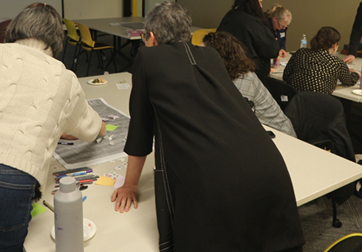
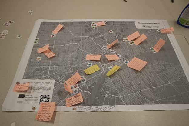
The two-hour workshop brought together diverse actors involved in studying, planning, implementing, and funding nature-based solutions (NBS) in Detroit. The workshop consisted of three different participatory activities. First, participants worked in small groups to map existing NBS in the city. They were given a large base map and a set of stickers representing different categories of NBS that were identified based on fieldwork in Detroit within the NATURESCAPES project: trees, rain (capturing rain), connecting corridors, native (flowers), food (security), and other forms of caring. Participants were asked to add projects on the map with the appropriate sticker and to label them and indicate what benefit(s) they were primarily designed to provide.
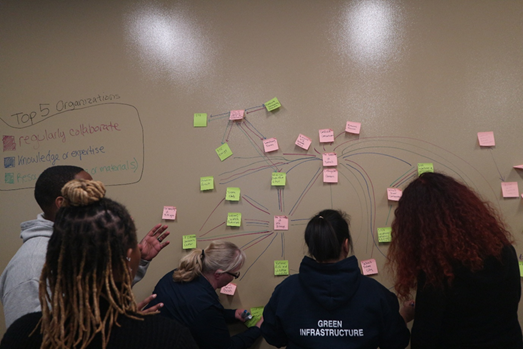
Second, participants mapped the actor network for NBS in Detroit. To initiate the conversation, we provided sticky notes with the names of key organizations involved in nature-based solutions in Detroit from previous research. Additional blank sticky notes were also provided. Participants were asked to draw three categories of connections between the actors: red for those that regularly collaborate, blue for those that exchange knowledge or expertise, and green for resources (financial or material). Third, reflecting on these bigger pictures ― the map and the actor network ― participants were asked to write and post their reflections from the first two workshop activities and associated conversations on sticky notes.
Mapping Detroit’s landscapes of care and its benefits
“It’s great to see all the work being done across the city!” ― workshop participant
The mapping activity sparked a lot of animated discussion among the participants as they shared their observations and experiences with various locations and nature-based solutions. A rich diversity of NBS projects were ultimately mapped ― from NBS that are capturing rain, connecting corridors, to trees, native species, food (security), to other forms of caring. Capturing rain was the most frequently mentioned NBS type, followed by native (flowers), and other forms of caring. The most important benefits listed include the fostering of connections between people and nature and among people (e.g., “neighbors helping neighbors”), (autonomous) food security, and flood prevention. While a diversity of NBS were captured on the maps, so-called “death zones” of NBS were reported (without (known) NBS), and some projects remain hidden, such as the reusing of vacant lots or nature’s “own interventions” in reclaiming spaces.
After the workshop, we combined the four paper maps and digitized the information to create an interactive web-based NBS map, which we also shared with participants. We hope this map can serve as a resource, demonstrating that the city is anything but “empty”.
NBS actor network
“Detroit is Detroit because of the network of non-profits doing the good work no matter what” ― workshop participant
The actor network activity visualized a diversity of well-established partnerships ― those who regularly collaborate, those who share knowledge, or those who share resources. Central actors in the network included NGOs such as the Greening of Detroit and Friends of the Rouge, but also actors such as the University of Michigan and philanthropic foundations appeared to play a critical role. While the network did not represent all actors working on NBS in Detroit, the community-driven nature of the work on NBS is evident. Missing from these accounts were organizations such as churches, block clubs, and Historically Black Colleges and Universities (HBCUs). As one participant observed, “This network is a sampling of the community-based organizations out there…HBCU, churches, CDOS, block clubs, sorority, fraternal groups. How are they representing the culture?”
Final reflections
“More voices to give us a deeper understanding of existing efforts and dreams” ― workshop participant
Participants ended the workshop by observing that many actors are bringing together benefits for the climate, biodiversity, and social justice agenda, but also raising concerns on the perpetuity of green space, unintentional outcomes of these connections (e.g., gentrification, concentration of power), as well as risks of duplications and wishes to “build on each other’s efforts in a more cohesive way”. A comprehensive plan for maximizing these green spaces, supported by a variety of voices and land conservancy, was seen as a way to leverage cohesion and ensure these efforts continue in perpetuity. Or in the words of a participant: “How is the land hosting Naturescapes protected in perpetuity?” In the future, connections between neighborhoods and across the region could be deepened, and there could be opportunities to leverage resources among organizations.
Acknowledgements: Thank you to all the workshop participants, Paul Draus and the University of Michigan Detroit Center for hosting the workshop, Séréna Aupoix for assisting with constructing the workshop, Consolata Macharia and Shaylynn Trego for assisting with the meeting facilitation and logistics, and Mahin Rahman for creating the online map. The workshop was supported by funding from the EU through the NATURESCAPES project (Grant Agreement No. 101084341) and the National Science Foundation (NSF) National Center for Atmospheric Research (NCAR), which is a major facility sponsored by the US National Science Foundation under Cooperative Agreement No. 1852977. The project upon which this article is based was funded through the NSF NCAR Early Career Faculty Innovator Program under the same Cooperative Agreement.
Sara Meerow and Anouk Fransen
Tempe and Utrecht
