
Read this story in Spanish here.
The gold miners had brought friends.
Ten days before a team of scientists, technologists and Indigenous guides was set to disappear into one of the most secluded rainforests on Earth, an illegal mining operation returned with reinforcements to Yaguas National Park. Tom Walla, co-founder of Limelight Rainforest, was in a hotel room in Ecuador packing his team’s equipment when the call came in. The Peruvian military was closing the park. “I’m looking at everyone going, ‘What do you mean it’s over?’”
It wasn’t over. But it wasn’t going to look exactly like what they’d planned.
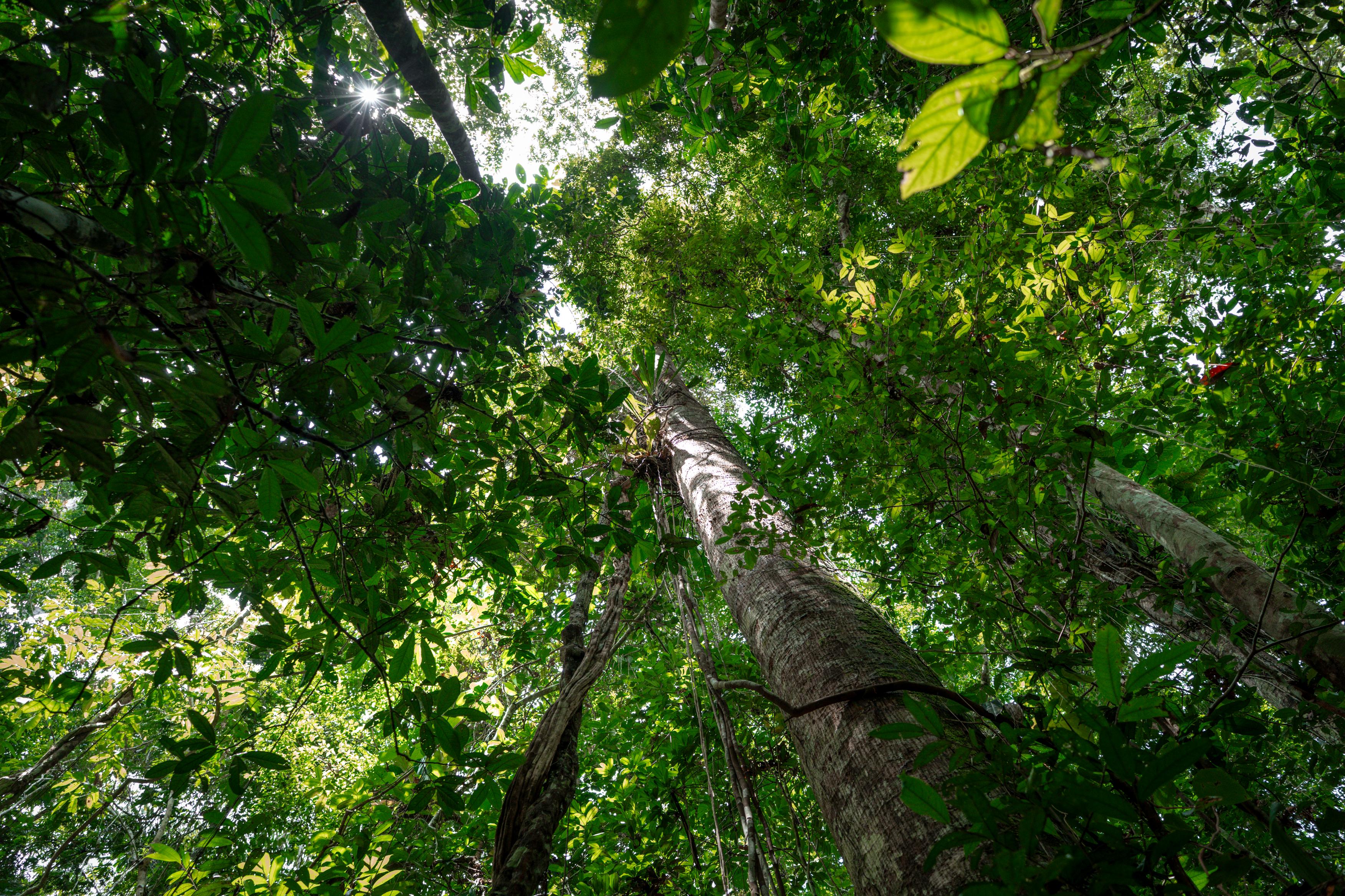
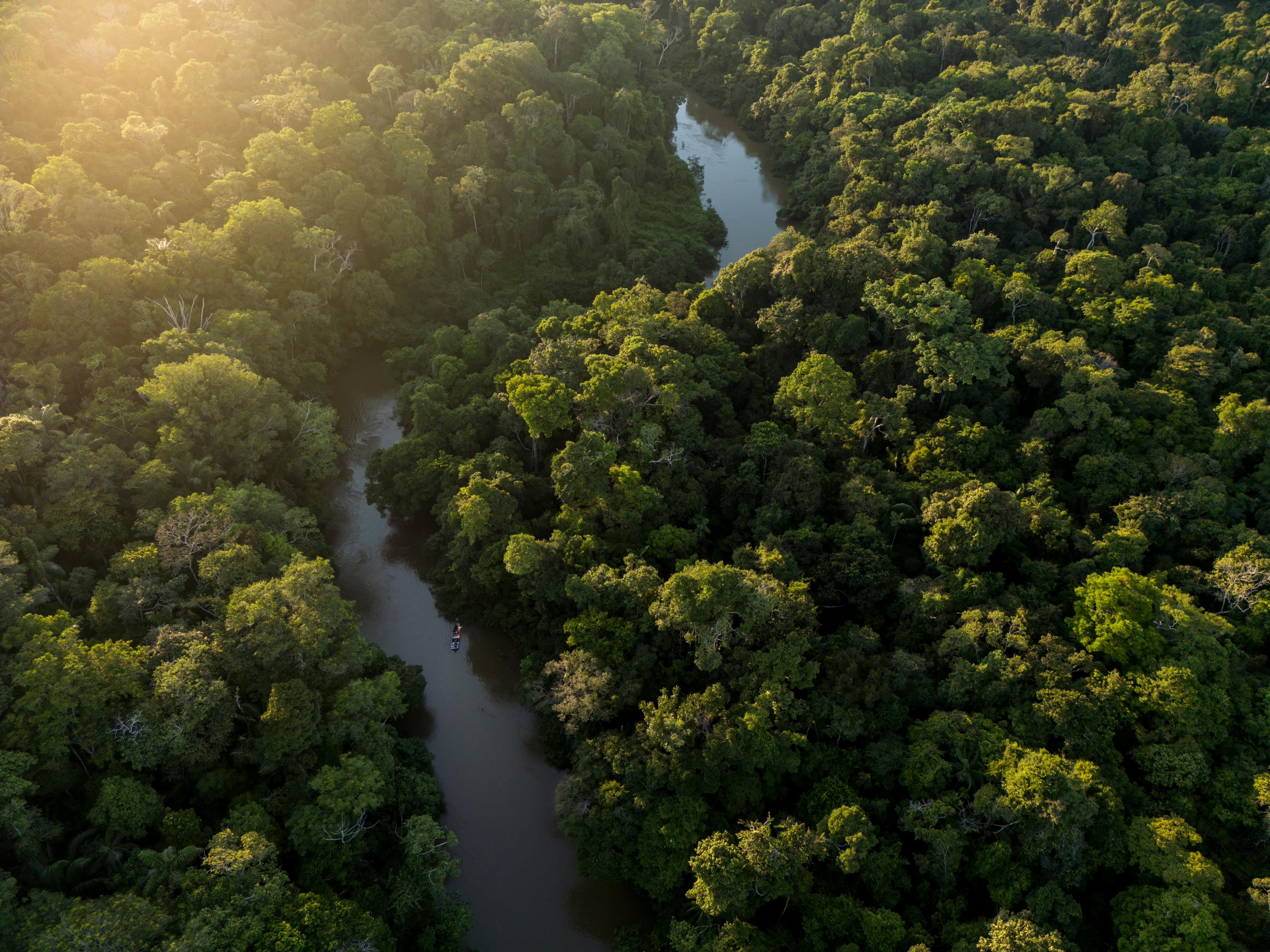
Yaguas, a protected area in the Peruvian Amazon roughly the size of Connecticut, is a haven for biodiversity. It is a labyrinth of unbroken rainforest, where the Yaguas River cuts through dense canopy, feeding sprawling peatlands that support endangered wildlife like giant otters, pink dolphins and woolly monkeys.
But for all its richness, Yaguas is a mystery.
“We don’t even really know what’s there,” said Ali Swanson, Conservation International’s nature technology lead. “Monitoring biodiversity at this scale, in a place this remote – we can’t really do it with any kind of rigor. It’s so hard to get there and prohibitively expensive to deploy.”
Swanson knew that solving this problem would require fresh thinking. The expedition — led by Conservation International’s Peru team, alongside scientists from Frankfurt Zoological, Okala and Limelight Rainforest — flew into the Amazon to test a theory: Can cutting-edge technology allow us to monitor nature at scale never before seen?
Armed with camera traps, bioacoustic recorders, environmental DNA samplers, AI-assisted drone mapping and a new generation of insect monitoring technology fresh from a global rainforest innovation competition, the team aimed to find out.
For Swanson, this is about more than scientific curiosity.
“This is one small expedition in one extraordinary place — a pilot, of sorts,” Swanson said. “But if we can succeed here, the implications stretch far beyond Yaguas.”
A place like Yaguas doesn’t just need to be understood — it needs to be funded. Rangers, boats, surveillance flights, rapid response to illegal incursions: none of it is free. Conservation International’s Peru team, which has worked in this landscape for years and helped lay the groundwork for the park’s creation in 2018, understood the problem intimately. The donors, governments and private investors who might provide that funding need something in return: proof. Proof that the forest is intact; that the wildlife is unique and irreplaceable; that the protection is working. Rigorous biodiversity monitoring, Swanson argues, is what makes that proof possible. Without it, even the most extraordinary places on Earth are difficult to defend.
The need for that defense became very real in the days leading up to the expedition’s departure.
From the hotel room in Ecuador, Tom Walla heard news of illegal gold miners slipping into Yaguas. They had been there before, but this time had brought reinforcements. The Peruvian military was now moving in. The park was closed.
He scrambled to make calls. “First it was you can’t stay at the station because our military is staying there. And then it was like, okay, we’ll beach camp. And then it was like, you can’t beach camp either. The whole thing just kind of melted.”
Luckily, Conservation International had friends in the forest.
On the outskirts
Jorge Gaviria had spent years working along these rivers.
His work with Conservation International-Peru focused on building livelihoods for the communities that border Yaguas — people whose lives are woven into the forest. When the park closed and the expedition needed a new home, Gaviria began reaching out to the chiefs of those same communities. Then he waited. Around him, the scientific teams and the Conservation International staff who had spent months planning this expedition, waited too.
“There were messages to community chiefs and then having to wait for their reply,” said Jeremy Cusack, chief scientist at Okala. “Bearing in mind that you have a whole scientific team bombarding you, wanting to know what’s happening.”
What was happening, it turned out, was Jorge. When the chiefs of Puerto Franco community replied, the expedition had a new home.
“At least 90 percent of the forest is intact,” Gaviria said. “The other 10 percent is where people live. It was the perfect place, right on the outskirts of the park.”
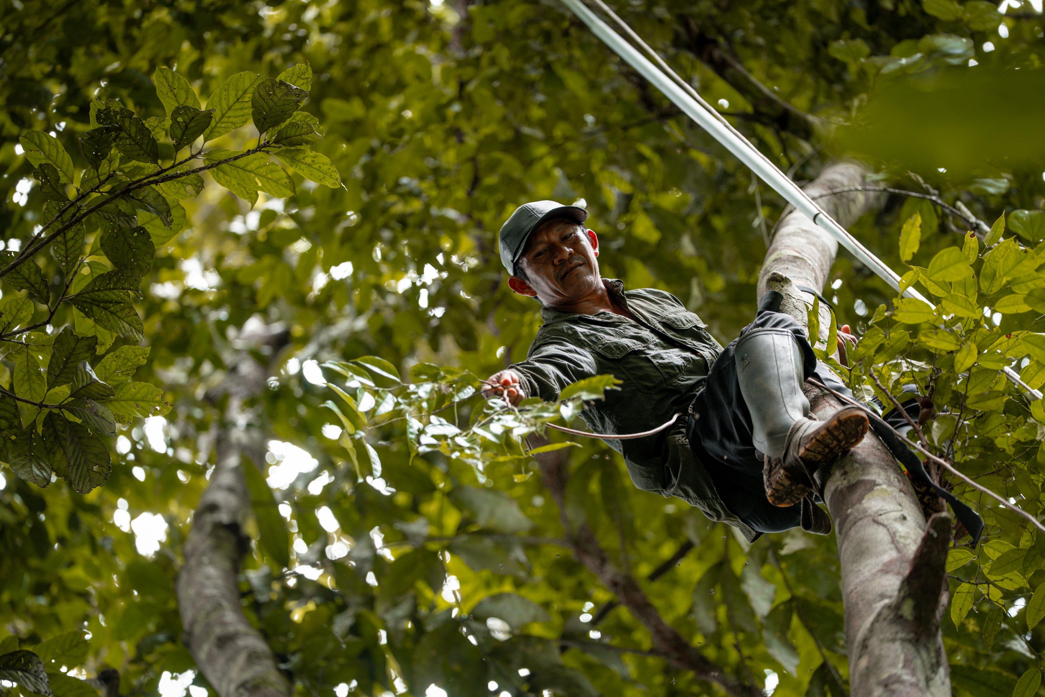
The camp that took shape on the banks of the river was designed to leave almost no trace. Despite twenty people in total — ecologists, technicians, botanists and members of the local Indigenous community — and enough equipment to stock a small laboratory, the forest around them remained undisturbed. Drones, camera traps. water sampling kits, racks of batteries and a Starlink terminal for beaming data to the outside world were all of tucked unobtrusively beneath the canopy.
“It’s like climbing Mount Everest,” Walla said. “To get each team two days into a rainforest takes a team of ten other people — cooks, boat drivers, mechanics. It’s an incredible list.”
At dawn, the teams scattered into the forest.
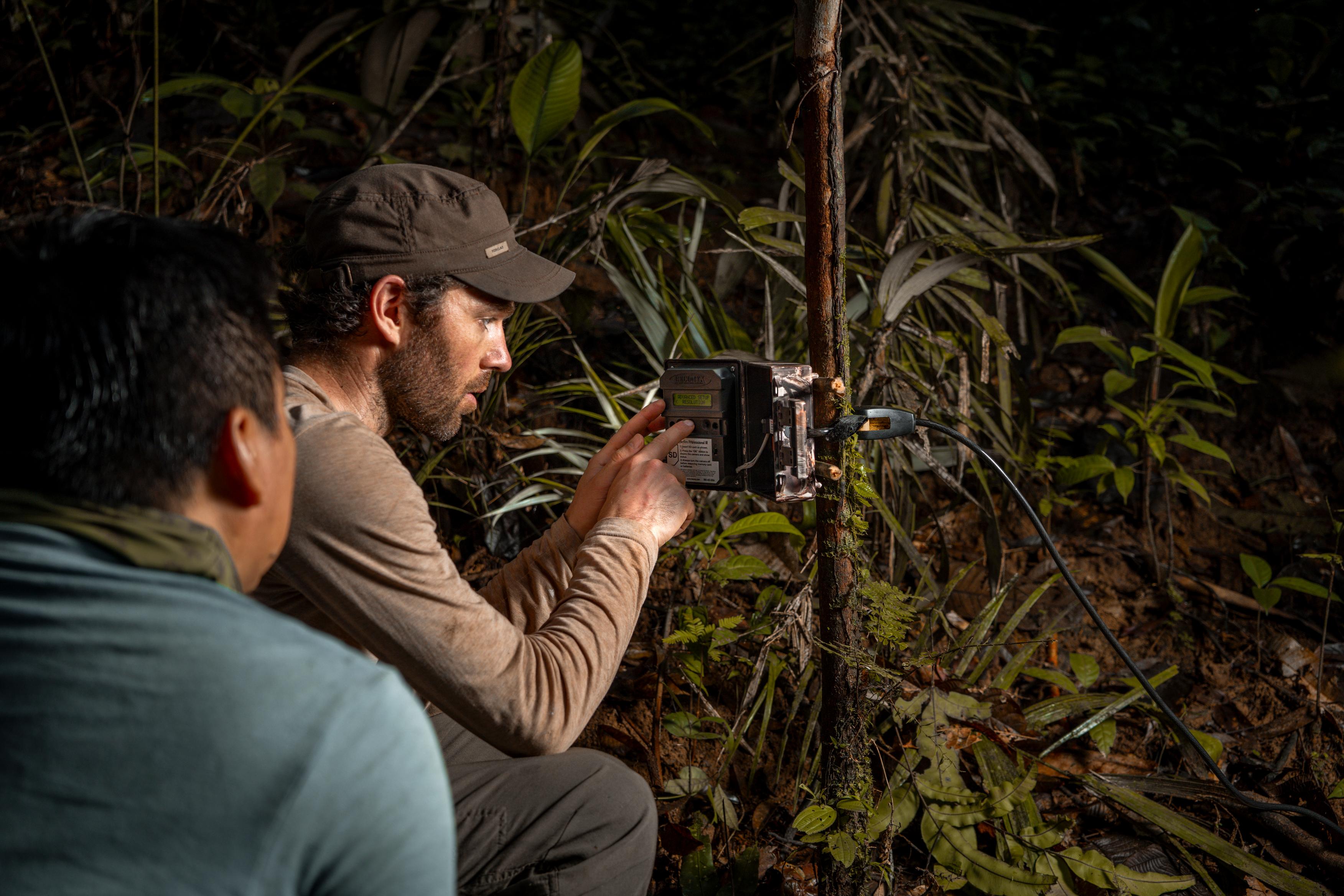
One group moved through the undergrowth placing camera traps — motion-activated devices designed to photograph whatever passed: jaguars, tapirs, the fleeting evidence of a healthy ecosystem. Another fanned out along the river’s tributaries, collecting water samples to be analyzed for environmental DNA — the invisible biological traces that every living thing leaves behind, while bioacoustic recorders were set up to capture every call, chirp and song from vocalizing animals like birds and frogs. Above the canopy, team members from Selvatek, an Indigenous biodiversity tech company, flew drones, capturing images so precise that individual tree species could be identified from the air. And in every direction, on trees and shrubs and the forest floor, the team placed a network of small LED lights that flickered as darkness fell.
Each technology was asking a different question. The camera traps asked: what moves here? The eDNA asked: what swims in the water? The drones asked: what grows here, and where? And the lights — the lights were asking something that, until very recently, nobody had thought to ask at all.
For a generation, the process for surveying nocturnal insects has been more or less the same — a powerful light trained on a white sheet. This low-tech method is like drawing a moth to a flame, or the flurry that meets a porch light at dusk. But on a good night in the rainforest, the resulting swarm can be unimaginable — a white sheet turned black with writhing arthropods.
“It’s like your first campfire,” said Walla, who has spent his career among entomologists. “You go out, you have a cold beverage, you look at moths on a sheet at two in the morning with a bunch of total insect geeks, and you learn to love the diversity of life.”
But Walla says that method has gaps — big ones. As specialists arrive with jars and tweezers, they collect the insects they recognize — the families they have spent careers studying — and they leave everything else. Not because the rest doesn’t matter, because there is no other choice. Nobody can identify it all. The specimens that do get collected end up in storage in the basements of natural history museums, stacked to the ceiling, waiting for experts who may never come.
“Staring at one of those sheets, you’re seeing a cross section of the diversity of all of nature,” Walla said. “And you collect maybe one percent of it.”
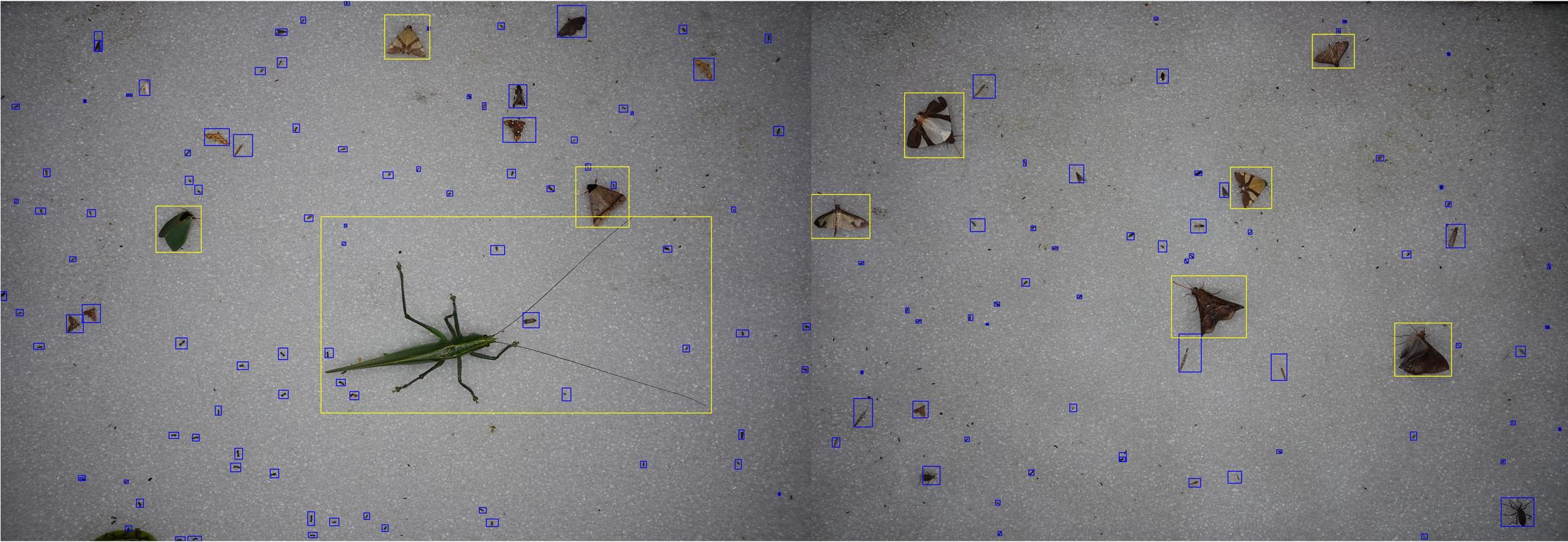
In Yaguas, things were different. There were still sheets and lights, but no one was standing watch with a beer. No one was even identifying anything in the field. Instead, a series of high-tech cameras continuously photographed everything that passed over the sheet — every minute, all night, for five days. The insects came, were photographed and disappeared back into the dark.
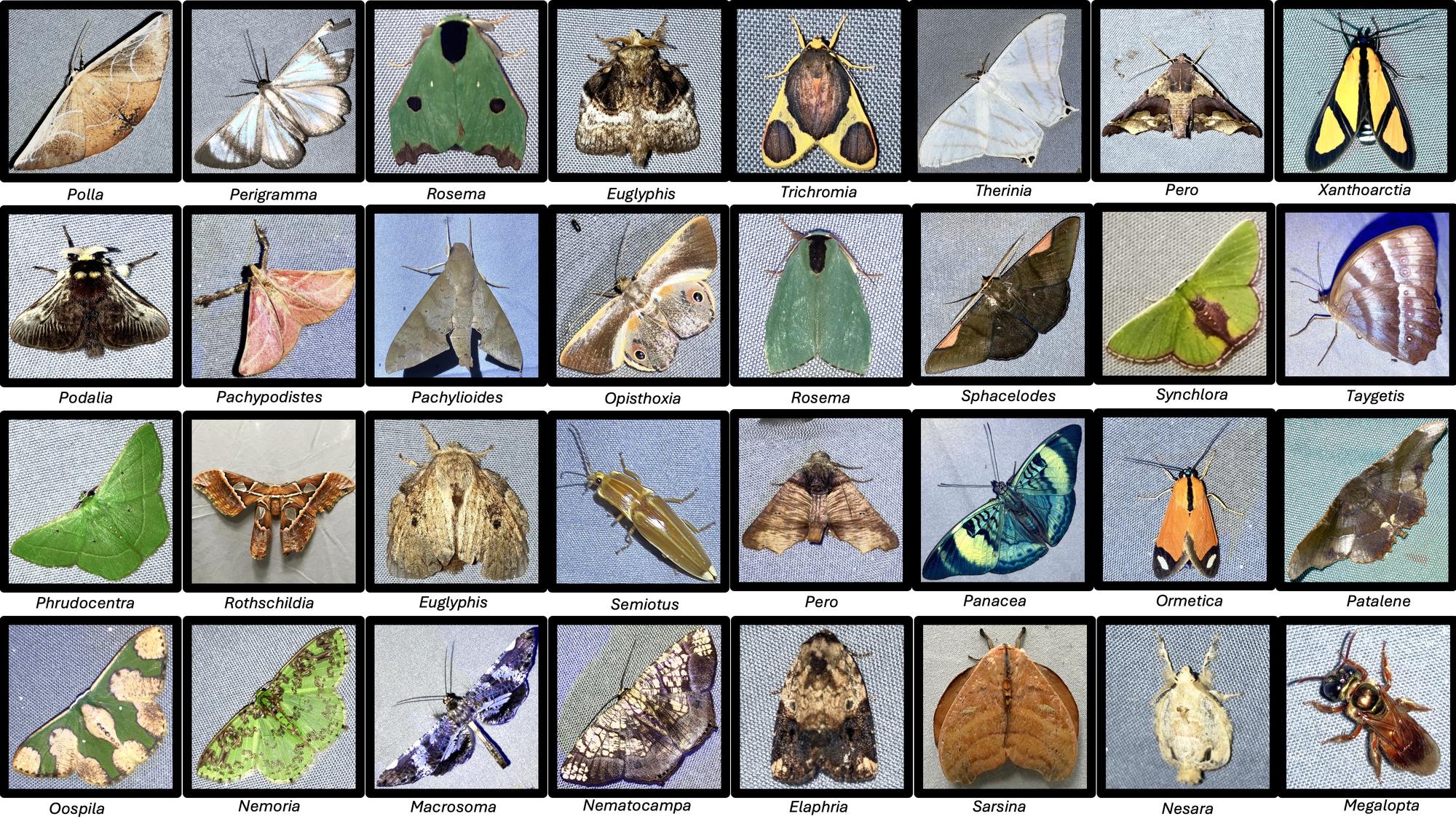
Back in the lab, powerful AI machine learning models went to work cataloguing and counting. Every organism that had appeared on every trap was measured — not to species, in most cases, but to the broader categories of family or genus; close enough to say something meaningful about the forest’s diversity of life. From five days of sampling, the team pulled 160,000 insect observations. Eight hundred and fifty-four taxa.
“It’s the worst ecological indicator of any group — that’s what I was told about insects my entire career,” Walla grinned. “Too variable. Too many to count. Too hard to identify. And they were right — until now.” He paused. “I’d argue insects are now the best indicator we have. Because we finally have the tools to read what they’re telling us.”
But the bugs were just a piece of the larger Yaguas puzzle the team was assembling.
For decades, the gold standard for biodiversity assessment in places like Yaguas has been Conservation International’s Rapid Assessment Program — RAP surveys, in shorthand. Teams of specialists parachute into a remote location, spend weeks cataloguing everything that moves, and emerge with a snapshot: an irreplaceable record of a place in time. A RAP survey of Yaguas conducted in 2010 was critical to establishing Yaguas as a national park.
But a snapshot is not a monitoring program.
“Our goal here is different than a RAP,” said Cusack, the Okala scientist. “We’re building something scalable across time — scalable across space — that can tell you what is changing, or why, or how fast. And in a remote and threatened wilderness like this, that is essential.”
With autonomous tools running simultaneously across multiple sites, a small team could gather enough data points to do something that had never really been possible before: extrapolate. To move from a handful of survey sites to a credible picture of an entire ecosystem — and to repeat it, affordably, again and again.
“You’re not monitoring all of the park,” Cusack said. “You can’t. But with the right tools in the right places, you don’t have to.”
The mathematics of scale
In November 2024, Ali Swanson boarded a small plane over Yaguas National Park. Beside her sat two park rangers, who carefully surveyed the dense canopy below.
Swanson had gathered with Conservation International’s Peru team to begin planning the expedition. When the local park authorities learned that they were planning a flyover, they insisted on a spot on the flight.
“That’s what we’re up against,” Swanson said. “These rangers are so strapped for cash that catching a ride with us was the only way they could survey the park and look for illegal gold miners.”
The entire annual budget for Yaguas in 2023 was roughly US$ 250,000. Compare that with Yellowstone National Park — roughly the same size as Yaguas — which operates on an annual budget of around US$ 77 million.
Yaguas’s rangers are inundated by illegal miners arriving by boat, loggers working the forest’s edges and the simple mathematics of scale — too few people, too little equipment, too vast a wilderness to watch. And the pressure is only continuing to grow.
“Yaguas is not an exception,” Swanson said. “Across the tropics, protected areas are designated on paper and underfunded in practice. The gap between what these places need and what they receive isn’t a bureaucratic oversight — it’s a structural problem, decades in the making.”
For Swanson, there is a direct path from data collected on missions like this one to actual dollars spent on conservation.
One potential financial opportunity are nature credits — a nascent but growing financial instrument that allows businesses and governments to directly fund verified conservation outcomes, in much the same way carbon credits have long allowed organizations to offset emissions. Peru’s Ministry of the Environment has recognized the potential and is developing a national nature credit framework. Conservation International is working to ensure Yaguas is ready when that market arrives — which is precisely why the monitoring data matters.
“Know what’s there, and be able to measure change,” Swanson said. “Whether we’re trying to unlock nature credits or other types of philanthropy — the thing we need in every case is proof. And right now, for most of the world’s protected areas, we don’t have it.
“If we want to have these places in 50 or 100 years, we need to be acting today.”
For the Indigenous people of Puerto Franco, that work has already begun. As scientists packed their bags and returned to far-flung corners of the globe, the members of this community were already home.
They had been critical to the mission’s success.
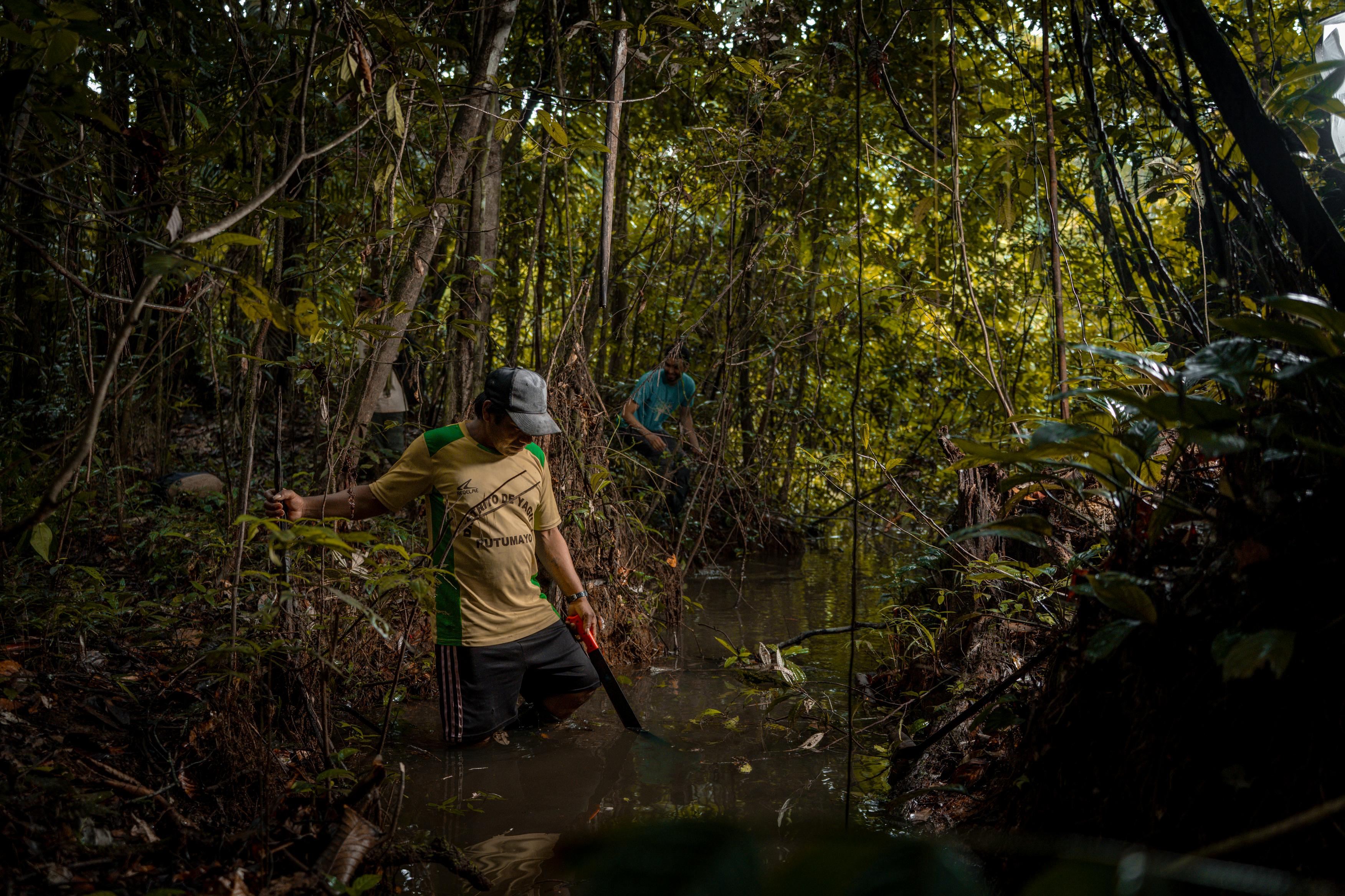
For five days, six members of the community had traveled with the scientists — trekking more than ten kilometers a day through the forest, installing sensors, activating traps, collecting data. When the scientists left, the knowledge stayed — and with it, the responsibility for retrieving the sensors and sending the data onward for analysis.
“Despite the exhaustion and the intensity of the work, it is very important for us to learn more about what we are already protecting,” said Luis Perdomo, a member of the Puerto Franco community and a member of the expedition.
Luis’s words echoed what Cusack believed this work could become.
“Eventually what we want is a station,” Cusack said. “Somewhere the sensors come in, the data gets transferred — and all of that is taken care of by the people who live there, who work there.” A rigorous, repeatable biodiversity record, flowing out of the forest and into the hands of the people who could act on it.
For now, in Puerto Franco, the sensors are still running. The forest is still there. And The case for Yaguas is being made, one data point at a time.
This expedition was led by Conservation International-Peru, with biodiversity monitoring designed and led by Okala and field technology provided by Conservation International, Okala and Limelight Rainforest and its affiliated team at Selvatek. The Frankfurt Zoological Society, a long-standing partner in Yaguas, has been instrumental in supporting the park’s protection since its creation in 2018. Funding for the technology innovation that made this pilot possible was generously provided by the Patrick J McGovern Foundation. We are grateful to the communities of the lower Putumayo, whose commitment to Yaguas long predates any expedition.
